People are often encouraged to leave their cell phones behind, or at least keep them in their pockets, when they enter a special place, to avoid distraction from calls or the Internet.
But the Friends of Brushy Hills are turning that recommendation upside down – at least when it comes to hiking a newly created tree identification loop in the Brushy Hills Preserve.
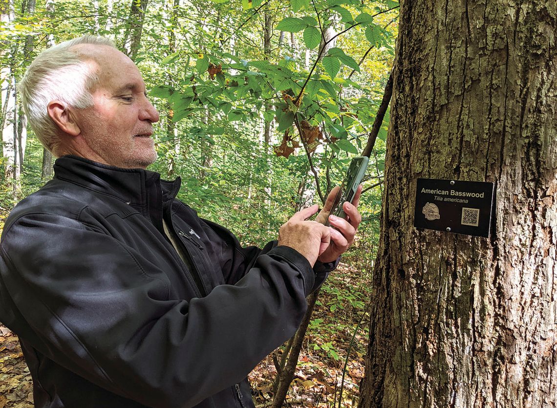
The half-mile tree loop begins on the Deer Trail near the stone springhouse on Union Run Road, turns left at the Up & Over Trail and then turns back to the Green Trail and the road. The loop features 25 specimen trees tagged not just with their common and scientific names but also with a “smart” QR code linking cell phones to a wealth of curated information.
Smart labels for some of the Preserve’s outstanding trees was the brain child of a trio of supporters: longtime Brushy Hills Friends Alexia Smith and David Rosher and more recent enthusiast Dan Walz of Lexington, who, after discovering the interest and beauty of the Lexingtonowned forest, wished ardently to know more about it.
“I’m one of those people who can learn the name of a tree but then all too soon forget it,” confessed Walz, a retired longtime director of the local Habitat for Humanity. He recalled mentioning his problem (surely shared by many) to Smith and Rosher, who were manning the Friends of Brushy Hills booth at the 2021 Rockbridge Community Festival. Soon, the three were putting their heads together for ways to help walkers identify and remember the trees in the Preserve, starting with the idea of labeling trees with their names and soon moving to adding more information via QR codes, cell phones and the Internet.
They knew that connectivity wouldn’t be a problem on Brushy Hills, where cell towers rise from the taller of the two Preserve hilltops. And accessing QR codes wouldn’t be a challenge, either, as most people with smart phones know how to do it. QR (Quick Response) codes were invented in the 1990s but became very popular during the pandemic, when restaurants and other retailers found it convenient to provide links to detailed information outside their establishments. To find a link, a user simply turns on a phone camera, points it at the QR code (but doesn’t take a photo), and then taps the link hovering just below the code.
Trees were selected for labeling based on species, condition and location. The labeled trees must reflect the diversity of the forest and should be well-grown and healthy, the Friends agreed. The trees must also grow close to the paths, so that hikers would not need to step off-trail and disturb the forest ecology to access the labels. In addition to the 25 labeled trees on the tree identification loop, nearly 80 more trees, covering a total of 55 species, were also selected for tagging in other areas of the Preserve, so that identified trees will be “sprinkled throughout,” Rosher said.
Some species will be represented more than once. For example, three different chestnut oak trees will each have labels. One of the labels will lead to information about identification, and the other two will also describe interesting features, such as a large burl on one of the oaks and impact from a lightning strike on the other.
For most of the linked information, the Friends created a template, starting with name and classification information and a description of the parts of the tree, including bark, flowers and fruit. Next comes interesting facts about the tree, written in an engaging narrative. There are also photographs, including some by Rosher, and live links to other websites, such as Virginia Tech dendrology and Minnesota Wildflowers (the latter chosen for its excellent photos and descriptions, said Rosher).
Helping with the tech side of the project was Peter Jetton, a Web designer and communications staffer at the Washington and Lee School of Law, and designing the Preserve logo, which also appears on the tree labels, was Rachael McKenzie, a neighbor and local fine arts teacher. The logo features the distinctive outline of a white oak leaf and the historic stone springhouse at the trailhead.
The tree labels were fabricated frin weather-resistant anodized aluminum, with an inconspicuous black background, to blend in well with the forest. Labels measure a generous 4-by-6 inches, so that squirrels or other creatures nibbling the edges won’t bite into the name identification or QR code, Rosher noted. The tags are fastened to the bark with spring-loaded screws, allowing for future growth of the tree. In a few cases, where the tree trunks aren’t large enough, labels will be attached to adjacent stakes.
While QR labels on trees are seen in other parts of the country, especially in parks and arboretums, they are rarely, if ever, seen in places where the trees haven’t been planted by humans but simply grow in the wild, like on Brushy Hills. But, for the Friends, the new technology and the old forest are a perfect match, especially since the forest is likely to need protection in the years to come. “If people can get to know the forest, they will be more respectful of it,” said Walz. “These labels are a great way to learn more about the trees – and to remember them.”
An inaugural guided tour of the tree identification loop will be held this Saturday, Oct. 21, from 10 a.m. to noon, and again from 1:30 to 3:30 p.m. Attendance for each tour is limited to 20. Register by sending an email to [email protected] . Rain date is Oct. 22, at the same times. For directions and more information about Brushy Hills, visit www.friendsofbrushyhills. org .
.jpg)


