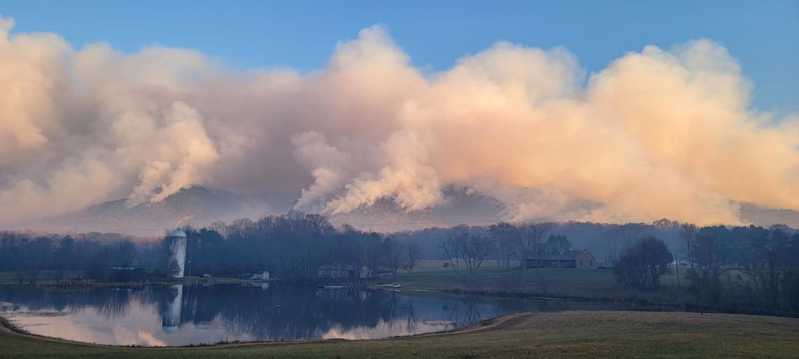
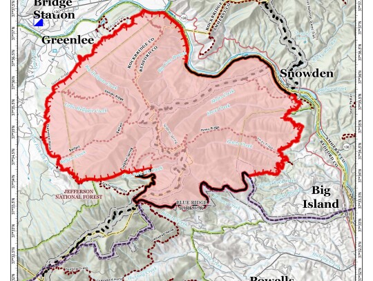
Tuesday morning - Today's rain is making a major impact on the Matt's Creek fire.
Below is the latest update from the Forest Service:
'A strong weather system with a large amount of moisture from the Gulf of Mexico and western Atlantic Ocean will bring "prolific rain" to the area today, according to Incident Meteorologist Christian Cassell. Rain will fall all day, intensifying in the evening, with a predicted 1-3 inches across the fire area. As a result, Fire Behavior Analyst Greg Titus said, "Due to the ongoing rain, fire spread is nearly impossible. Do not expect to see active fire today." Due to the good work done to contain the fire, lack of active fire and concern over public and firefighter safety during heavy rain, firefighters will take a pause from field operations today and focus on training and equipment maintenance at the Incident Command Post. Tomorrow, they will return to the fire area to continue work to contain the fire and begin repairs to areas affected by fire suppression operations.
'Operations: Yesterday, firefighters continued to improve, mop up and patrol fire lines around the fire perimeter. The fire moved off slopes on the western side of the fire where firefighters conducted an aerial strategic firing operation on Sunday. Firefighters helped bring the fire to containment lines on flatter ground with tactical firing, closing gaps of unburned fuel between the fire and the control lines. Structure protection specialists assessed structures in the Hunt Camp Road area on the eastern side of the fire and in the Arnold Valley area west of the fire.
'Investigators have determined that the small, 0.75-acre Hercules Fire near Snowden was caused by human activity and was not the result of a spot fire from the Matts Creek Fire. The Hercules Fire was contained and is in patrol status. The cause of the Matts Creek Fire is still under investigation.
'Personnel and equipment on the fire include 7 hand crews, 15 engines, 4 helicopters, 2 water tenders and 1 drone.
'Weather and Fire Behavior: With the rain, no active fire behavior is expected. Heat remains in larger fuels and in areas where vegetation is sheltered from the rain. Temperatures will remain in the lower 40s and easterly winds will be 5-10 miles per hour with gusts of up to 12 mph. For tomorrow, temperatures will increase to the mid-50s and northwest winds of 15-20 mph with gusts of up to 30 mph. ' '
Noon Monday - The Matt’s Creek Fire has now consumed more than 10,000 acres on National Forests.
According to this morning’s update from the Forest Service, 317 people are now on the scene in an effort to contain the fire. It is considered 27 percent contained.
The following is the report from the Forest Service
“Yesterday, firefighters conducted a strategic firing operation south of
“In the northeastern portion of the fire, near Snowden, crews continued to improve fire lines and the area is looking very good and forward progression has stopped. Crews will search for and extinguish any “hot spots” in logs, stumps and under the ground.
“In the southeastern portion of the fire near
“In the southwestern area fire lines have held well, increasing containment to 27 percent.
“Firefighters continued to watch the Hercules Fire, a small fire that started yesterday across the
“Today, firefighters will work within the strategic burn operation to locate and extinguish areas of heat and monitor the fire. Crews will also continue to improve existing fire containment lines and patrol the
“Personnel and equipment on the fire include 6 hand crews, 15 engines, 4 helicopters, 2 water tenders and 1 drone.
“Today, temperatures are expected to be in the lower 50s with humidity between 40-60 percent. East winds will be between 5-10 miles per hour, turning east/southeast during the afternoon. Tonight will bring increased clouds and possibly some light winds after midnight. For Tuesday, rain is expected to remain steady and may possibly become heavier at times. Rainfall may be 1-2 inches and is anticipated to fall throughout the day. Winds will remain 5-10 mph with an occasional gust of up to 14 mph. Fire activity is expected to pick up later this afternoon. The strategic firing operation helped move the main fire front over slopes and into flatter areas. This will provide safer access to firefighters and allow a greater chance to successfully stop the fire from spreading to the west.”
“Heavy smoke is likely in communities and along roadways near the fire area today. An incident air resource advisor issues smoke reports at https://outlooks.wildlandfiresmoke.net/outlook For more information on air quality visit AirNow.gov. Please use caution when driving in low-visibility areas.
9 a.m. Sunday - The Matt's Creek fire in Bedford County has grown to over 6,800 acres and is considered about 15 percent contained.
The following report was posted by the Forest Service this morning:
"Matt's Creek fire continues to move around in the heavy leaf litter and shrubs within the Thunder Ridge NF Wilderness Area southeast of the Natural Bridge. Yesterday's winds pushed active fire edges on the west flank of the fire, resulting in additional fire spread between Belfast and Big Hellgate Creek towards the James River. Light west winds today will slow fire activity and reduce smoke production into the evening. Warm and dry conditions will continue to support fast fire growth in the continuous leaf litter. Visit Inciweb for closures, contacts, and more information."
As far as smoke goes, expect very unhealthy conditions between Bedford and Lexington. "Light west winds will disperse smoke along I-81 and the Blue Ridge Parkway. Today's clear skies, light winds, and warmer temperatues will produce short periods of reduced roadway visibility and pockets of heavier smoke concentrations along drainage and valley bottoms. This evening, smoke will continue to settle in communities between the Natural Bridge, Buena Vista, Amherst, and Lynchburg. A cooler, moist air mass is moving into the area Monday night bringing improved air quality."
4 p.m. Friday - Firefighting efforts are ongoing as the Matt’s Creek Fire, located in the James River Face Wilderness, continues to grow.
The fire has grown from an estimated 3,600 acres Thursday evening to 5,148 acres as of 3 p.m. Friday, according to the U.S. Forest Service’s incident information system.
At that time, the fire was 2% contained.
The Forest Service has brought in an incident management team to direct firefighting efforts.
At a press conference at midday on Friday at an overlook on U.S. 501 east of
“Right now, there’s no foreseeable threat to structures,” he said. “We expect to contain this to the forest.”
There are currently over 250 people involved in the firefighting effort, and more coming.
“We have people from all over the country, based on their skill level,” said Mazzeo.
Outside help will leave local volunteer departments free to respond to emergencies or smaller fires in their area.
Efforts have been complicated by the terrain of the face wilderness.
“If you’re familiar with the terrain, how steep it is, we cannot get firefighters in there, for their safety. Firefighter safety is our top priority, so we let the fire come up to us, where they can safely address it,” said Mazzeo.
A “fire line” has been created in the vicinity of Snow Creek, to block the spread. Mazzeo said the goal is to create another line around Petite’s Gap.
While the cause of the fire is still unknown, Mazzeo said that the volume of fallen leaves helped its spread.
As firefighting efforts continue, hunters are asked to remain clear of the area.
Burn bans are also in place throughout the region.
Updates will be posted at https://inciweb.wildfire.gov/incident-information/vavaf-matts-creek-fire.
Meanwhile, shifting wind is starting to bring some relief from the heavy smoke that has enveloped the Rockbridge area. The smoke level was considered hazardous this morning, but the winds are now producing moderate smoke levels here. Moderate means that unusually sensitive people should consider limiting prolonged or heavy exertion outside.
The winds from the north are expected to push the smoke eastward, although
11:30 a.m. Thursday - The Matts Creek Fire has grown to approximately 2,750 acres.
According to a late morning update from the U.S. Forest Service, the fire in
Resources on the fire now included approximately 120 firefighters and support staff, seven fire crews, four engines, and three helicopters.
Winds will be light today so smoke may occur in nearby communities. For information on air quality visit AirNow.gov. There is an air resource adviser who is issuing smoke outlooks and installing air monitors.
Early Thursday morning - The Matts Creek Fire grew to approximately 2,500 acres by Wednesday afternoon.
According to a late afternoon update from the U.S. Forest Service, the fire in
The fire is located 5 miles southeast of
The entire fire is on National Forest lands, there are no structures threatened.
The fire was reported on Sunday. The cause of this fire is undetermined.
As of Wednesday, there were approximately 120 firefighters and support staff on the scene, along with six fire crews, one hot shot crew, two engines, three helicopters, and two fixed-wing air tankers using water only.
Smoke from the fire was heavy in many parts of Rockbridge County Wednesday, and local school systems closed today in anticipation of an even worse day today. However, the clouds that were containing the smoke Wednesday are gone today, allowing some of the smoke to dissipate.
For information on air quality visit AirNow.gov.
A number of Forest Service trails are closed, and the
.jpg)


