

Snowstorm Kicked Off Wild Week Of Weather
The long-lingering ice from early January’s winter storm had seemingly only just melted when a second major snowstorm hit the area last week.
Starting with snow in the early hours of last Tuesday, the Rockbridge area experienced a full spectrum of weather events over the course of a week, as snow, rain and wind each took their turn battering the area.
After the snow had fallen and begun to melt, rain on Saturday and early Sunday caused creeks and rivers to rise, though officials reported minimal flooding. By Sunday afternoon, the winds picked up and downed trees and disrupted power through Monday morning.
And several inches of precipitation and many fallen trees later, area citizens were bracing for yet another winter weather system today, Wednesday, that promises snow.
First, The Snow
The first round of severe weather came in the form of heavy snowfall last Tuesday, with totals ranging from 7 inches to over a foot across different parts of the county. The accumulation led to treacherous road conditions and numerous vehicle incidents.
According to Rockbridge County Fire-Rescue Chief Nathan Ramsey, emergency responders were dispatched to 27 motor vehicle incidents across the county, including two tractortrailer accidents on the interstate.
“To my knowledge, there were no major injuries or fatalities. Some people may have been transported to the hospital,” Ramsey said.
The storm contributed to one of the snowier winters in recent years. As of mid-February, an estimated 17 inches of snow have fallen in the area, already surpassing the combined total of the last two years. It’s the snowiest winter since 2022, and with more flakes in the forecast, the area may be looking at the heaviest season in six years. However, it remains below some of the most extreme winters recorded in the county’s history, such as 2009-2010, when snowfall reached 35.1 inches, according to records found at weather.gov.
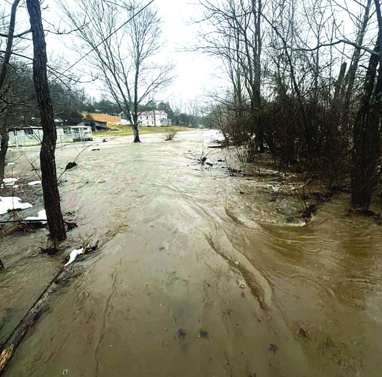
BLACKS CREEK in the Collierstown area overflowed its banks in this photo taken by Santana Ayers Sunday morning. She was one of several area residents who posted flooding photos on the newspaper’s Facebook page.
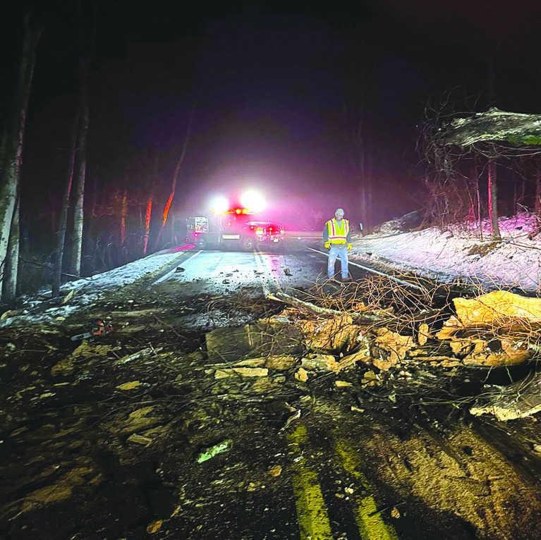
ROCKBRIDGE BATHS Fire Chief Mel Bauernfiend responds to a downed tree call Monday morning at 5:30 at the intersection of Maury River and Farm House roads. The department responded to seven tree calls in 12 hours.
The snow also disrupted school schedules. Rockbridge County Public Schools Superintendent Phillip Thompson explained that the district has been monitoring its snow days carefully, and last week opted to have “virtual learning days” on Wednesday and Thursday after canceling classes on Tuesday.
Explaining how snow days and make-up days work, Thompson said, “Each year we include several ‘bank days’ when we create a school calendar. For the current school year, we built in 10 additional ‘bank days’ in case of snow, flooding, or some other reason we would need to close schools.
“Due to the recent snow, ice, and flooding back in the fall, RCPS is currently sitting at three remaining ‘bank days,’” Thompson said. “When we arrived at a place where we only had four days left, we worked with our building administrators to develop a plan for utilizing ‘virtual learning’ days.”
Virtual learning days, utilized during the pandemic, mean that learning can continue even when school is closed. Students work on school assignments from home, and teachers are available for questions and communication throughout the day.
They also help school administrators avoid adding days to the school calendar. “In the past, when we had to add days to the calendar, it often meant we had to reduce or cancel spring break, add days to the end of the school year, or have school on Saturdays,” Thompson said. “Thankfully, virtual learning days are an option that has been made available to us for up to 10 days.”
Then, The Rain
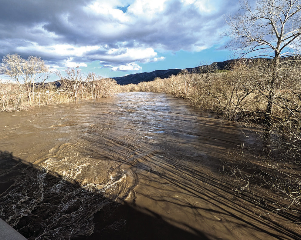
A prolonged period of rain Saturday and early Sunday added another layer of concern for an already saturated landscape. With melting snow increasing runoff, local creeks and rivers rose throughout the day. However, flooding remained limited, with no major road closures reported.
“The streams and rivers did get up, but we didn’t have any major road closures that I was aware of,” Ramsey said.
Buffalo Creek, which is monitored by a gauge at Murat, reached 7 feet — considered minor flood stage — but did not cause significant disruptions.
For local farmers, the rain and melting snow presented both benefits and challenges. Virginia Tech Extension agent Tom Stanley noted that while the moisture was much needed after a dry period, the resulting mud created difficulties.
“The most lasting effect of last week’s snow is to make a significant step toward restoring our soil moisture levels after a long period of dry weather,” Stanley said. “Of course, the mud that comes with it is treacherous and frustrating, but the high winds have helped dry out the topsoil.”
And The Wind
As the skies cleared from the rain, however, strong winds moved through the county Sunday afternoon, bringing additional challenges. Trees toppled across roads and power lines, with Ramsey confirming that emergency crews responded to 29 calls for service related to blocked roads.
“Which is fairly busy, but it’s normal,” Ramsey said. “Anytime a tree is completely blocking a road in the county, the fire department goes to help VDOT.”
The windstorm also left hundreds without power. As of Sunday afternoon, 690 power meters in Rockbridge County remained without service, according to FindEnergy.com. Dominion Energy crews had already been working around the clock since the earlier snowstorm, restoring power to 90% of the 220,000 customers impacted across Virginia.
Dominion spokesperson Jeremy Slayton reported that Sunday’s windstorm alone affected 439 Rockbridge customers, while the earlier snowstorm impacted about 120.
“As is common for the type of storms our service area experienced – winter ice/snow storm and a strong wind storm – we saw a lot of tree damage, downed wire and broken poles,” Slayton said. “Our crews worked as safely and quickly as possible to restore power to all of our customers.”
Among the trees that went down Sunday was the Great Oak at Boxerwood, estimated to be 150 years old. More on the tree will be featured in next week’s paper.
Looking Ahead
After a week of winter extremes, Rockbridge County appears to have weathered the storm with no injuries or widespread damage. The story is not over yet, though — with at least an inch or more of snow in the forecast for today and a history of March snowstorms during wet years like this one.
After continued cold temperatures this week, however, the immediate forecast is for temperatures in the 50s next week.


Weather Scenes